Quantcast
Channel: TO THE MAX
Viewing all 110 articles
Browse latest View live

Hiking the Lost Coast Trail, California

$
0
0

A few weeks ago I took a casual stroll on a 25-mile section of the Lost Coast Trail with college friend Anna Joseph. This section of California’s coast was too mountainous to host Route 1 and remains relatively remote. The “trail” follows sand and rock beaches and runs along the edge of decomposing cliffs. There are several sections that can only be passed at low tide, which adds an element of risk and planning to the walk. Photos are below and you can find more logistical information here.

Anna tasting energy bars for Outdoor Gear Lab

Me in my usual hiking outfit.

Deceased sea creature.


The MSR Nook at one of our campsites.

Rock hopping in the Outdoor Research Axiom shell.

Anna exploring an abandoned lighthouse.

View from the lighthouse.

Me enthusiastically chomping down on a Pro Bar.
Not on the Lost Coast Trail, but in Redwood National Park. Anna shows how big trees can grow.


Bishop bouldering: a week of moderate classics

$
0
0
My first bouldering trip, if a bouldering trip is one that exceeds two days in length, was last week. I did tons of classic moderates in Bishop. My goal was to do as many three star problems as possible. Highlights include the Hulk, Atari, Strength in Numbers, Molly, Serengetti, Suspended in Silence, Jedi Mind Tricks, and many more. Some images below.

The money shot from the trip: Anna Joseph sends Fly Boy Arete, her first V5.

The tablelands during a snowstorm.

Cruising Atari.

On top of Atari.

The Pollen Grains. Jedi Mind Tricks, a classic highball V4 is in the center.

Another classic highball V5 (Suspended in Silence) that starts with an all-points-off dyno from the large chalked hold at the lower left.

Anna enjoying the Buttermilks.

Someone cranking hard with lots of Organic pads beneath.

New Four Season Tents

$
0
0
I've been testing a bunch of new four season tents. Hilleberg Nammatj, Nallo, Keron; Brooks Range Invasion; Stephenson's Warmlite 2R; MSR Dragontail, Twin Sisters; Mountain Hardwear Direkt2; Sierra Designs Convert 2; and more. The focus has been on finding the best lightweight (<4lb.) single wall tent. Unfortunately, no one makes a tent out of non-woven dyneema, which would be better than all the materials used in the ones we're testing.

Here are two panoramas from the past week.

MSR Dragontail

From left to right: Brooks Range Invasion, Stephenson's Warmlite 2R, and Mountain Hardwear Direkt2

Regular Northwest Face of Half Dome: a daylong mini-epic

Bosavi Tour: Dan Freschl and his headlamp

$
0
0

Dan with Bosavi prototypes on display.
Dan Freschl is a man everyone can look up to. He had an idea, to build a better headlamp, and is following through with it all by himself. 

The Bosavi story officially starts a few years back when Dan bought a mill on Craigslist and started playing around with it. After some success he bought a larger computer controlled mill, also on Craigslist, but this time behind his wife’s back. He mentioned it to her briefly and she threatened to divorce him, but he bough it anyway. (They’re still married.) The newer mill is a 3000 lb. behemoth of a machine that he operates with the grace gained from rebuilding it ground up and programming the numerous operations that have shaped the countless versions of Bosavi’s injection molds and heat sinks. 

Bosavi's custom lithium polymer battery. The whole lamp is built around it.
 
The mill is just one of many projects Dan has tackled solo. He designed and built his own circuit boards, website, logo, t-shirts, he wrote his own patents, and has jumped the hurdles that larger companies with clear with one hundred people, all by his lonesome. Dan and Bosavi are proof that you can do it.

His shop lies within the larger confines of Joshua Tree Furniture, a Berkeley-based woodworking shop that makes tables, cabinets, and various other artsy things. I found Dan starring at his laptop in the company’s showroom. Early Bosavi prototypes, parts, and graphics occupy a five-foot by three-foot display in the center of this space. This was the first gallery I’ve been to that features a prominent display of headlamps.

Joshua Tree Furniture Gallery. The Bosavi display is on the left wall.

Bosavi’s relationship with the furniture company seems to be a good fit for Dan. Finding lots of small wood scraps laying around the shop, he milled early versions of Bosavi out of fine hardwoods like ebony.

His primary workspace rests in the back of the shop and is cluttered with Bosavi ingredients. The place looks like an infant was left alone with a large bowl of electronic spaghetti. Circuit boards, wires, LEDs, and batteries cover the counters while notes, numbers and diagrams cover the walls. In an email he warned me about the mess. “Hope you don't mind seeing how I really work.” 

Although the Bosavi shop may appear messy to an outsider like myself Dan knew where everything was and quickly assembled the majority of a headlamp before my eyes. For the most part he avoided technical engineering speak, but I learned that Bosavi’s LEDs blink 400 times per second (the human eye can only handle about 40) and he showed me all of Bosavi’s programmable options and features. The list is impressive: you can charge Bosavi’s lithium polymer battery with almost any power source (USB, AAA batteries, solar), the headlamp can mount to a bike handlebar, and the packaging folds into a lantern. My first impression two favorite features: 1) the unit folds down not at the strap like most other headlamps, but in the middle, which keeps the center of gravity closer to your head, and 2) it’s surprisingly compact, which is great because it takes up less space in your pack or your pocket.


Circuit boards.

Injection mold for part of the elastic strap mount.
Bosavi will be built in China by the same factory that makes these. Dan is going there soon to check it out.
Bosavi seems like an excellent lifestyle headlamp for people on the go, people in cities, and people who play outdoors. The rechargeable battery offers numerous advantages and cost savings over traditional batteries, and every detail of the headlamp has been meticulously thought out. If you want Bosavi or want to support Dan and his DIY efforts check out the project’s Kickstarter page. There’s only a few days left!

A Bosavi prototype. Note how the beam adjusts from the center of the lamp, not the back. This keeps the center of gravity closer to your head.
Watch Dan talk about building Bosavi:

SlingFin Tour

$
0
0
-->
SlingFin lies at 5th and Gilman in Berkeley.
SlingFin is a badass outdoor industry startup. They’re located in Berkeley, California on Gilman Street (the historical epicenter of the outdoor industry) and are building ultra high quality gear. Earlier this week I dropped in for a tour of their shop and to talk tents with their young very knowledgeable crew.

SlingFin builds things for people who spend lots of time in the mountains. Not car camping lululemon wearing weekend warriors. Their team consists of ex-Mountain Hardwear founders supported by young Jedi warrior gearheads. The company’s design philosophy is expedition driven; they made durable goods. The model is simple: start with products for use at the top of the highest mountains and work down in elevation from there. Expedition style tents are ready now, down garments and backpacks are in the works, and eventually they’ll move into lighter tents. But the focus, they say, will remain on hardcore users. 

Expedition tents, down garments, and river rafts in the SlingFin showroom.


“Our methodology is purely design and quality driven. No undue influence from marketing managers, “bean counters” or “suits.” Utilizing our innovative designs and the best materials available we design and build gear for professional guides and serious users. Period.”

I spent the majority of my two hours in the shop with Martin Zemitis, the godfather of tent design and SlingFin’s headman, and Devon Brown, an ex Mountain Hardwear warranty guy and jack-of-all-trades. They showed me the Hardshell tent, which Outdoor Gear Lab will test, and a handful of other upcoming projects. Going over one of their products takes a long time. Whenever I inquired about a particular part, such as the small plastic clips that attach the tent body to the fly, Martin and Devon would dive into a passionate ten-minute lecture on the evolution of that particular part, fabric, or coating. Even a veteran New York Times reporter would have trouble taking notes fast enough. I recorded the conversation. And when it turned to plastic clips they sprayed me with a brief history of their role in tent design, the many types of plastic, and why their custom clip is the best on the market. If only marketing and public relations people could speak so eloquently about the products they promote…

Martin Zemitis helped to design the left clip, currently used on the Mountain Hardwear Trango, and improved upon its design with the right clip, used on SlingFin tents.
Reinforced stitching on the LFD tent.
On the day I visited SlingFin’s shop was both cluttered and organized at the same time. Down jackets and screen-printed shirts hung neatly on one wall while spare arts and fabric swatches lay strewn about elsewhere. The younger team members, who have no titles, huddled around a central table with what appeared to be their personal computers. SlingFin is a startup that doesn’t accept cash from corporate monsters that want to influence its products. They’re about to put an innovative backpack, codename Honey Badger, on Kickstarter. Watch for it.

Devon Brown, SlingFin's everything man, poses on a massage table inside the LFD tent, a 5 meter dome.

 Around 1:30pm, and after much debate, we settled on a location for lunch. Cheap and delicious Indian food filled our stomachs (I had the best mango lassi of my life) and we discussed gear and the outdoor industry. “What’s your favorite piece of gear?” “What’s your favorite factory tour?” They asked me. I learned, among other things, that one employee had a personal collection of sixty tents. Another is known to be so hard on gear his name is now used as a verb, meaning to abuse gear. The environment was California casual. Martin, the equivalent of the company’s CEO, was dressed in jeans and a worn grey Yeti Coolers t-shirt (Yeti makes the best coolers for fishing and river running, both of which Martin enjoys). He knows more about gear than most people alive, has worked in the industry forever, and yet was incredibly down to earth and welcoming.

Companies like SlingFin push the outdoor industry forward with progressive designs and ruthless attention to detail. Unless you’re a high altitude mountaineer hang tight for a few years until they release tents for lower elevations.

Evolution Traverse: best alpine rock traverse?

$
0
0
Earlier this month I did the Evolution Traverse, which is arguably one of the best alpine rock traverses in the US. A full trip report is and video can be found here.


Bike tour: San Francisco to Los Angeles

$
0
0

There are some things you absolutely must do in life. One of them, I’d been told by native Californians, is to ride a bike from San Francisco to Los Angeles down the Pacific Coast Highway (Route 1). Not wanting to miss out on a "California classic", yet also not much of a cyclist, I mentally prepared myself for days of dreadful butt pain and asked the most experienced bicycle tourist I know (my high school friend and fellow ski racer Maggie Smith) to join me for the ride.

We set out from San Francisco at 7:00am on Sunday May 27th. The air was cold and humid from the grey fog that covered the city. I was clad in my newly acquired bike touring armor: tight fitting black spandex bibs, white polyester socks with a line of blue and yellow bicycles around the ankle, awkward and clunky Shimano clipless pedal shoes, and black and white bike gloves. My bike, a late 1990’s Lemond Zurich, was no longer minimalist and speedy. It was a pack mule loaded down with two panniers and crowned with a six foot orange flag that screamed, “DON’T HIT ME!”

Departing San Francisco
The first few hundred feet from the house were steep and I struggled to balance the unwieldy metal and rubber beneath me. Like a newborn baby breathing in for the first time I was nervous in this new world of bike touring. Maggie, who came equipped with quadzillas for legs and has ridden across (and all over) the country, looked calm, stable, and at peace on her bike. When we reached the crest of the first hill she began to instruct me on the basics of bike touring. I learned to start breaking early, to use my hands to signal potential hazards, and to walk my heavy bike with one hand on the seat and the other on the handlebar.

It was Memorial Day Weekend but the city was empty. For others, Sunday morning was for sleeping off Saturday night’s hangover or for a luxurious brunch at a French Bistro. But we were bicycle tourists and we were going to Los Angelels!!

So we pedaled. Rotation after rotation propelled us down the coast. We passed the beaches and sand dunes of the Outer Sunset District and rode on through Daly City, and down through Pacifica. This wasn’t so bad, I thought. I can do this.

We stopped for an energy bar break at the top of our first climb, the windy Devil’s Pass. While sitting at the edge of a cliff looking down three hundred feet at the deep blue crashing waves, Maggie and I reaffirmed our goals for the trip; we were doing this to see the California coast, to get a break from “normal life”, to catch up, and for fun. That night we camped 10 miles north of Santa Cruz at the “local’s only” 4.5 mile beach. Total mileage: 72.

Campsite at 4.5 mile beach

Day Two was one of berries, fish, and barbeque.
We left our heavenly beach site and rode through the back streets and country lanes of Santa Cruz, Watsonville, and Castroville. If you buy berries at the supermarket you’re likely familiar with Watsonville, the strawberry capital of the United States and home to Driscoll’s (owned by the fruit giant Dole) who grows, packs, and ships strawberries and raspberries—to even the smallest of markets in faraway places like Maine.

Castroville, twenty miles of strawberry fields south, is the artichoke capital of the world. There, field after field of unruly, threatening artichokes grow like giant cacti. They stick their leafy heads high up in the air and, when the time comes, a tractor hovers above and decapitates them. After a day in the fruit and artichoke kingdom we arrived at our destination, Monterey, in time for a tour of the town’s gorgeous aquarium. That night we feasted on grilled portabella mushrooms, avocado, fancy cheese, and drank wine with Maggie’s friends.

Watsonville strawberry fields

Monterey Bay Aquarium jellies!!
Heading south from Monterey the scenery got better and better. We pedaled through 17-mile drive (a posh gated community), Carmel (posh retired white person community without a gate), and started down the Big Sur coast. Travel guidebooks say that Big Sur is one of the best drives in the nation. If only the guidebook authors could have seen it on a bike! Riding slowing, we teetered at the edge of one thousand foot cliffs that plummet into crystal blue waters. Although every point was a vista point for us, the people in cars-- those gigantic climate controlled couches with surround sound-- flew by, missing our views. They stepped out of their vehicles in designated pullouts and gathered together, cameras snapping, jaws dropping. California!!

17 Mile drive near Carmel.
Maggie rounding a turn on the Big Sur Coast.
Our first crisis struck at Pfeiffer Beach. We were camped on a cliff among monterey cypress trees (endemic to Moneterey and Carmel) when it happened. The most novice camping mistake ever: I spilled our pasta in the dirt. The pot toppled off our little MSR Micro Rocket and over went our gorgeous penne noodles. Their center holes, which normally fill with gooey cheese and savory sauce, were riddled with dirt, small stones, and bits of cypress bark. I sat down, stunned, and started laughing. I, the veteran camper, “the camping technique and gear guru” who’s slept all but 12 nights outside in the last 9 months, just botched our meal.

I though the noodles were ruined but Maggie told me, in a highly confident tone, “Max, we are going to eat this pasta.” So I volunteered to go down to the creek, where I swished and shook the pot for nearly thirty minutes. A passing hiker asked if I was panning for gold. No, I thought, I’m trying to get the forest out of our penne!!After most of the rocks were out I blew through each noodle and carried the mushy, glutinous remains back to Maggie for inspection. She declared that we would split each noodle in half and wipe out the residual dirt with our fingers. We sat together, with the pot held fast between her quadzillas, and repeated, noodle after noodle: split, swipe, wipe. The crux of our assembly line was preventing one noodle’s dirt (which sticks to your finger) from contaminating the next noodle. I wiped the gunk on my white socks with the blue and yellow bicycles. Finally, when finished we mixed in tuna, avocado, bell peppers, and cheese- which collectively masked the mutilated remains of the noodles. And we toasted, with a bottle of Cianti Classico Reserva 2008, to Big Sur and to noodle cleaning-- may we forever and always bike tour with angel hair noodles (which don’t have holes).

 Maggie optimistically picks up noodles (left). Our finished meal (right).
Back in the saddle again, my bike no longer felt awkward, clumsy, and heavy. We were one again. My muscles anticipated the effort required to push us forward, my brain could better estimate the time required to stop, and I felt less ludicrous looking in my clunky mismatched biking apparel. With increased confidence and comfort, the rest of the trip flew by.

California undergoes a dramatic transition at Big Sur’s southern border. Northern California turns to Southern California. The change is visible in both the land and the people that inhabit it. The topography levels out, the air temperature increases, and there’s less precipitation. The people dress better, the dogs get smaller, the houses less attractive, and the cars turn from multi-color to either black or white (the colors of luxury). Maggie and I started into “So Cal” the day we rode 85 miles from Kirk Creek Campground to San Luis Obispo. The next day we went another 85 miles to Lake Cachuma, a massive 400+ site campground outside Santa Barbara. Along the way we passed Michael Jackson’s Neverland Ranch and the birthplace of Hidden Valley ranch dressing. At Lake Cachuma campground we met Gary, a local fisherman who invited us over for cocktails, a campfire, and story time. He and his family entertained us with the area’s history, gossip, recommendations for things to do that we didn’t have time to do, and warned us of the pass we had to climb the next day.

 Guadalupe, CA
 Rolling hills of Southern California. 
The pass proved to be a long gradual climb up two thousand feet. The opposite side of the mountain was steeper, curvier, and thrilling to descend. We dropped down from the hot grasslands to the cool coast, and into Santa Barbara County. That night we camped in Carpinteria, a quiet beach town just south of Santa Barbara, and the next day we rode up to Ojai, our final destination. Of the thirty or more homes I’ve crashed in during the past year few can match the generous welcome we received from Tom and Becky Lowe. At their home we boxed up our bikes, laundered our clothes, filled our stomachs, and talked about, among other things, Patagonia(Tom has worked there since the beginning). The next day we rode with Tom to Patagonia’s headquarters for an extensive half-day tour. We met Jess Clayton (Outdoor Gear Lab’s PR contact), Evan Daniel (an up and coming alpine designer), Val Franco (longtime do everything specialist) and Lee Turlington (VP of Global Product)— we got an excellent peek into life at Patagonia. That afternoon we took a short train ride south to Los Angeles, spent the night with my sister, and flew out of LAX the next morning. 

This trip opened my eyes to the wonderful world of bike touring. Out of all of the possible ways to travel long distances in the frontcountry none are as fun, as affordable, or as spontaneous as bike touring. Thanks Maggie!


North With You: Five Weeks in the Brooks Range

$
0
0

I stood on the sidewalk in downtown Anchorage waving a purple and red sign that said “North with you! :)” Sarah was 50 feet in front bobbing double thumbs up to the oncoming traffic. Her bright pink jacket helped to catch people’s attention. Nine rides later, the equivalent of driving from San Francisco to Seattle, we stepped out of an 18-wheeler at the beginning of the route we drew in Google Earth. From there, we walked and rafted west nearly to Kotzebue. 524 miles in total. Across the equivalent of several Northeastern states. Without roads or trails. 

BROOKS RANGE 101
  • 11,800 people and 235,000 caribou live in far north Alaska, an area the size of California. 39 million people and zero caribou live in California.
  • Gates of the Arctic National Park, the size of Maryland, sees perhaps 500 annual visitors and has no recreation infrastructure (trails, toilets, bridges, etc.)
  • 120 million year old mountains range from 3,000-9,000 feet in elevation.
  • The near absence of glaciers make long distance travel possible without technical skills; unlike most ranges in Alaska, you don’t need to be a ski mountaineer to experience the landscape. 

Our route in red.
GPS coordinates of our campsites, wildlife sightings, and the 132 antlers that came within 30 ft. of our path are here. Our gear list and commentary are here.

THE HITCH
Arguably to a greater degree than elsewhere, people in Alaska care a lot about how much time they’ve spent in the state. The longer you’ve been here the better. Double bonus if you were born in the state. Growing up a bush community gives you mad ups.

One of the men we rode with told us “I’m born and raised and I’ve never left!”
“Never left?!” I asked.
“Well,” he confessed, “I rode my motorcycle into Canada once.”

The crux of the hitch was getting a ride from Fairbanks north to the start of our route. Most of the traffic on the Haul road is commercial—truckers pulling food, fuel, and equipment; pipeline workers; geologists and ecologists employed by extractive industries and the institutions that regulate them—folks who are prohibited from picking up passengers. At Hilltop Truck Stop, the last commercial entity before the road turned to dirt and became remote, Sarah spent a few fruitless hours asking truckers if we could go north with them while I spent a few fruitless hours waving the sign by the side of the road. Eventually, she became tired of soliciting the truckers and asked me to take over. The first man I asked said, “Sure, I don’t mind.”

Meet Dick Brennan, grandpa and Haul road. veteran. He helped to build the road in the 1970’s and has logged three million miles on it since then. That’s the time equivalent of spending 16 continuous years of his life traveling between Fairbanks and Prudhoe Bay. Naturally, we learned some trucker jargon:

“Shake the load loose” = get started
“Four wheeler” = car or truck with four wheels
“Keep your foot in it” = don’t slow down
“Blow” = winter storm. Bad blows have kept him idling, stationary, for five days. “Sometimes you can’t see your hand outstretched in front of your face.”

At his office, Dick manipulates pedals, shifters, and buttons while witnessing the Arctic landscape transition from winter to summer and back again. During the colder months, when oil and gas activity peaks, he drives on ice roads up to and out on the Beaufort Sea. In the summer he watches moose, caribou, and millions of migrating birds from his triple thick windows. We averaged 2.4 mpg over the 310 miles to our desired drainage, then Dick continued north pulling a 60,000 lb. oil-water separator.


Thanks to Dick Brennan for bringing us the final 310 miles.
HAUL ROAD TO ANATUVUK PASS  (60 miles)
Hugging the continental divide, this was the easiest walking we encountered. The weather was perfect, the tussocks sparse, and the caribou antlers prolific. We planned to take four days to get to Anatuvuk and did just that; we slept in until 10, took photos and Gaia GPS locations for all 115 antlers that came within 30 feet of our path, marveled at permafrost sink holes, talked and cried about commitment in our relationship, and enjoyed long lunch breaks in the sun.

We called this a "permafrost sink hole"
Melting soil
Caribou antlers!!

Musk ox
ANATUVUK PASS  (0 miles)
We expected to walk into town, find the post office, pack our bags with the goods we mailed there, and walk out of town an hour later. However, we ended up walking out of town one week later!

We learned the post office had been closed for the previous three days because the post mistress was at a hospital in Fairbanks caring for her sick baby boy. Neither the store employees, the policeman, the ranger, nor folks on the street knew when she would be back. Sleeping at various locations outside of town, we walked to the airstrip each day at 9 a.m. and 4 p.m., hoping to see her step off a plane.

Bush Alaska continues to exist in large part because the United States Postal Service contracts with flight services for daily mail delivery. This dramatically lowers the cost for flights to regional hubs, and allows people to get free shipping from Amazon and have fresh food delivered from Fred Meyer. One man we talked to was waiting for a trampoline ($90 with free shipping). A sport hunting guide was waiting for dog food ($20 per bag with free shipping). Like us, other visitors were waiting for resupply food: ten NOLS style hikers from Wisconsin, two hikers from Switzerland, and two hikers from California and the UK.

We purchased calories from the Nunamiut store and debated whether things were cheap or expensive. A small loaf of preservative-filled bread cost $8. Bananas were $2.50 each. Ripe bananas from Ecuador to an Arctic village for only $2.50 each! Sarah couldn’t resist.

We spent several days talking with Al Smith, Anatuvuk’s National Park Service ranger. He is the most impressive ranger I’ve ever spoken with: engaged in the local community, immensely knowledge about its history and culture, and an excellent teacher. We asked him questions hour after hour, day after day, excitedly following down history’s winding paths, our eyes jumping from wall to wall as he referenced the maps, books, and articles that covered every square inch of the office (see photo below).

Learning from Gates of the Arctic National Park Ranger Al Smith
By the time the post mistress arrived, the building was packed to the ceiling with packages. We helped her search through the stacks on stacks on stacks of boxes to find one of the two for us. The food arrived, but, due to shipping confusion in Anchorage, our boat would arrive four days later.

We visited with Al, built rock towers along the river bank, enjoyed pizza night with Al (he wore a Pizza My Heart shirt), hiked up a nearby peak, played midnight basketball with the village kids, and ate lunch with aschool teacher’s family.

To provide some flexibility, we built an eight-day loop in the Arrigetch, home to the Brooks Range’s best rock climbing, into the middle of our route. For the first few days I was disappointed and angry about the delay in Anatuvuk. I REALLY wanted to explore the Arrigetch! By the fourth day, however, I realized how valuable our time here was: we had a rare period of time free from obligations and distractions, and I learned a great deal about Brooks Range geography, history, and culture.

The ranger station cost $1,000,000 to build.
Our camp at the end of the airstrip (white pyramid shelter)
Diesel, flown in and heavily subsidized from north slope oil revenue, powers Anatuvuk Pass generators.


The 8 x 8 Argo is the vehicle of choice for hunting.


ANATUVUK TO WALKER LAKE  (160 miles)
This was the driest summer in the last two decades and it followed one of the driest winters on record; the John was running low and bony. We paddled through slow meanders outside of Anatuvuk, dragged the boat through the majority of a four-mile long rock garden, and enjoyed blissful Class II paddling on crystal clear water farther downriver.

Among other ways, we knew we were getting farther from Anatuvuk because the frequency of aluminum can sightings, resulting from the village’s love for soda, was decreasing. We switched muscle groups and walked up Wolverine creek in the creek, seeing hundreds of small fish and stepping over and on thousands of boulders, almost all of the 23 miles to the first pass.

We walked the boat through the majority of this four mile rock garden.


11 p.m. views of the Arrigetch. Let's camp here!
Sarah ripped her pants in the brush near the top of a pass and took them off to fix them before they tore further. A brown bear strolled up about 20 feet away. He/she caught us off guard, with our packs splayed open, and Sarah’s pants down. “Hey bear, sorry to bother you. We’re just passing through. Trying to repair our pants.”

Due to her greater respect (which is not to say I lack respect), Sarah became our wildlife relations manager: She directed my behavior, oversaw the handling of bear spray, led us in the creation of audible deterrents, and dictated our terrestrial and aquatic navigation when large mammals were present. 

Over time, our audible deterrents evolved from "Hey Bear" to "Hey Deer" to "Hey Dear," to "Hey Sexy,""Hey Baby,""Hey Sugar Mamma,""Hey Baby Cakes," etc.

Once the snow melts, water in arctic creeks comes primarily from melting tundra. Walking in the Nahtuk almost all the way to the Alatna was very cold. Our legs and feet were refrigerated. Numb. Stiff. Hard to feel what was going on down there. A narrow, boulder and log choked canyon sent us several hundred feet up steep slopes with thick brush. A few minutes passed before Sarah noticed the alders had snatched the lower third of a trekking pole. This prompted a unpleasant, obsessive hunt for the foot-long piece of carbon fiber and a resolution to wrap the bottom sections in pink duck tape when we returned home.

The Nahtuk running low (left)  One of the canyons we climbed around (right)
Walking in the lower Nahtuk.
Wading in the lower Nahtuk--exhilaratingly cold and spooky.
When we reached the Alatna we walked hundreds of feet across gravel bars to the green, slow water. The river was shockingly LOW. We stopped paddling to admire, discuss, and record video of the first contrail we saw in two weeks. The white streak was a reminder of the global economy in which were, at the moment, connected to only via our clothing and equipment. 

Blowing up on the Alatna.


We were frigid cold the first day of paddling in the rain with temps in the low 40’s. Our legs and butts were soaked because we neglected to put on our rain pants in the morning. Big mistake. Our hands were not working wellit took five minutes to open the boat’s inflation valve, which is normally a simple twist of the thumb and forefingerbecause we didn’t start the day wearing our rain mitts. Big mistake. Sarah was borderline hypothermic, which gave me a rare opportunity to convince her to take big bites of cheese straight from the two pound block. This would never happen normally, as she hates the sticky feeling of biting into a chunk of cheese and the resulting, persistent smell from cheese particles that remain jammed in your teeth and gums. But we both warmed up from eating and running back and forth on the gravel barenough to agree to get back in the boat and keep paddling. A drysuit would have turned the day, and though we didn't know it yet, many subsequent days, into Type 1 fun.

Rain continued as we left the Alatna and crossed west through unnamed, seldom visited watersheds. The brush was far denser than expected and we became soaked from thrashing and bashing. To combat the now mid thirties temperatures, we shoved chocolate and cheese into our mouths.

The terrain was mysterious with ever-shifting clouds, deep spongy mosses, willows yellow from the onset of fall, and steep peaks with tiny remnants of glaciers. At 11 p.m., as it was beginning to get dark, we were climbing up steep grassy slopes near the top of a pass when we realized we were in a bear den. We could see the many places the bear(s) had laid down and were overpowered by a creepy, eerie feeling. Another way to phrase it is: downright terrified. But we were exhausted and didn’t want to drop back down and spend an extra hour schwacking up another way through the twilight. So we kept climbing up the steep, wet mountain, and spoke to the bears with utmost sincerity: “Hey bear, we’re sorry to walk through your home. We’ll be over the pass in ten minutes. Please let us by. We’re very sorry to bother you!”

The next day, we put on soaking wet clothes, schwacked down to the Kobuk, paddled gorgeous blue waters while watching a huge bald eagle twirl above us, schwacked a few more miles through bogs to Walker Lake, then paddled a few miles to our resupply point at the Helmericks house on Swan Island. We arrived, bone tired, out of food and fuel, at 11 p.m. to the sound of our friend Richard Baranow’s hammer.

Mid 30's and soaked. Brrr.


11 p.m. paddling on Walker Lake...almost to Swan Island!
WALKER LAKE (0 miles)
We spent two and a half days resting, eating, and repairing gear at the Helmericks' home. We showered, washed our clothes in the sink, made four repairs to the boat, patched our wind and rain pants, taped a large tear in the groundcloth, repaired a PFD, and the lace loops on Sarah’s shoes. For breakfast, we cooked potatoes, eggs, and sausage Richard flew in. YUMMO! For dinner: hamburgers, beer, and ice cream! YUMMO! We even stayed up to 2 a.m. sitting in a couch watching a movie while eating popcorn and brownies! YUMMO! All in a house on an island, in the middle of a lake, in the middle of the largest contiguous Wilderness area in the world.

There’s nothing else like the Helmericks' home in the Brooks Range. It started in the 1940’s when Bud and Connie dragged a canoe up hundreds of miles of rivers and spent a winter in the cabin they built with hand tools. They crossed over the range the following spring, floated 300 hundred plus miles north on the Coleville to the ocean, and spent a summer with the eskimos. They became some of the first white people in Prudhoe Bay. Bud developed into a big name hunting guide and brought people like L.L. Bean to the cabin. They raised children there and, later, Bud built a two-story house on top of the cabin. One winter they snowblowed a gigantic runway on the lake so a large plane could bring in building materials. The couple wrote a series of popular books including "We Live In the Arctic,""Our Summer With The Eskimos,""Our Alaskan Winter,""Flight of the Arctic Tern, and "The Last of the Bush Pilots."

Richard has worked on the house for the last six summers. This year, he built a gorgeous 25’ x 15’ deck on the second story. With an elaborate winch system of his design, we helped him install the stairs and a solar panel to trickle charge the house batteries. Staying there and seeing artifacts of the old Alaska was an absolute privilege and a highlight of the trip.

The Helmericks' guest cabin, built in the 1950's, decorated with our freshly sewn, glued, and washed gear.

2 a.m. bonfire with Richard. 

Sarah carried these rocks between 50 and 130 miles! Richard flew them back for her.
Protection from my poor casting.
WALKER LAKE TO AMBLER (197 miles)
Due to the abundance of glaciers, there aren’t many large, clear rivers in Alaska. The Kobuk is one of the state’s beauties. The upper part of the river was absolutely fantastic. We floated through crystal clear water over tens of thousands of chum salmon, grayling, char, and sheefish. 

Each evening we saw five to ten brown bears walking the edge of the river looking for chum. Satiated by the abundant food, they gave us nary a glance. 

Seagulls dive-bombed the small black boat and its colorful paddlers. The paddlers deflected the assault by waving their paddles overhead. Resorting to other methods, several bold gulls launched aerial fecal attacks. The paddlers watched white excrement fall through the air and land nearby. Plop. Again. Plop. Later, an expert marksman hit the spray deck between the paddlers, missing them by a few inches.

We portaged around the upper Kobuk canyon and lined the boat around the class III parts of the lower canyon. Later that day we encountered people for the first time in 15 days: two high-level fly fisher folk from Anchorage. We gave them a pixie, a type of fishing lure, that we found outside of Anatuvuk and they gave us several homemade flies and fancy hand line—the ultimate ultralight fishing setup. Unfortunately, for various reasons including lots of rain and the need to build a fire in order to cook fish, we never used their generous gift.

Soon, the river divorced topography and remarried a vast landscape of sinuous channels, and tundra. It was a country with big skies and big weather systems--country that nourishes Sarah’s soul. The cranes called to her. The temperatures dipped below freezing. The tundra was orange and red. As we paddled, we played hangman and 20 questions, sang songs, and watched eagles, osprey, cranes, and swans.

Fish camps, where (primarily) Alaska Natives catch and dry fish, became more frequent as we traveled downstream
We had twenty minutes of shirts off summer paddling. It was wonderful.


Avoiding the rapids (out of the frame to the left) at the end of Lower Kobuk Canyon. Note all the exposed rock.
The gravel bars on the upper Kobuk were a rock hunter’s paradise. Every bank was filled with brightly striped, speckled, and swirled rocks of blueberry to grapefruit size. We collected six pounds worth, an exercise of great comparison and deliberation, and stopped in Kobuk (population 150) to mail them home. Someone in there told us the river was the lowest in living memory.

At some point before Kobuk, the river turned from a gorgeous delight into, for me, a boring slog. The views became rare to none, the banks became monotonous and rose ever higher above us, and the low flow made the river feel like a lake. We accidentally referred to the river as a lake. Paddling into the wind was brutal.

Our uncomfortable boat became nearly intolerable. We were kneeling for 12 hours a day with our feet twisted up underneath us, soaking in cold water. I used my paddle as a crutch to get out of the boat and as a cane for the first few minutes of hobbling around. Our feet were swollen, red, and bruised. We began to take stretch breaks every 60–90 minutes. I didn’t regain feeling in all of the toes on my left foot until a week after we got home.


Sinuous! Note the old channels and 8/19 campsite label. The photo below shows that site.

Sometimes we found it faster to pull the boat.
AMBLER TO KIANA  (107 miles)
Our extra day at Walker Lake and the slow riverwe’d averaged around 3.5 mph when we estimated at least 5 mphput us behind schedule. Even if we paddled a minimum if 12 hours per day we estimated there wasn’t enough time finish to go to Kotzebue. I wanted to bail—to fly to Kotzebue and then home, and spend a few days cooking nice meals and relaxing indoors before Sarah left for Utah. She, however, insisted that we continue what we set out to do. We had a hard talk, packed up our copious quantity of tip-top quality resupply food, repaired an eight-inch tear in the boat’s “kneeling dragon,” and decided to voyage onwards to Kiana, the closest village to Kotzebue. From there, we would hop on a plane to Kotzebue ($160) before flying commercial to Anchorage.


One evening I wrote:

Quiet. Immense quiet. Huge wilderness. Nothing threatening. Aching body. Sitting up hurts. Always want to lay down. Loving the uncertainty and anticipation of new food.


The Great Kobuk Sand Dunes are the star attraction of Kobuk Valley National Park. I was expecting a trail from the river with a sign. Neither of those existed. The first place we pulled off the river was a wolf den—hundreds of prints and myriad trails through the brush—so we began the mild three-mile walk from farther downstream. When we got home I called the park service and learned they estimate 60 people visit the dunes each year. Most years everyone flies in and stays only a few minutes. The other visitors we saw on the river—canoeists with boats and supplies that made our setup look like a jail cell—had no interest in schwacking and continued downstream saying, "We've seen sand dunes before."

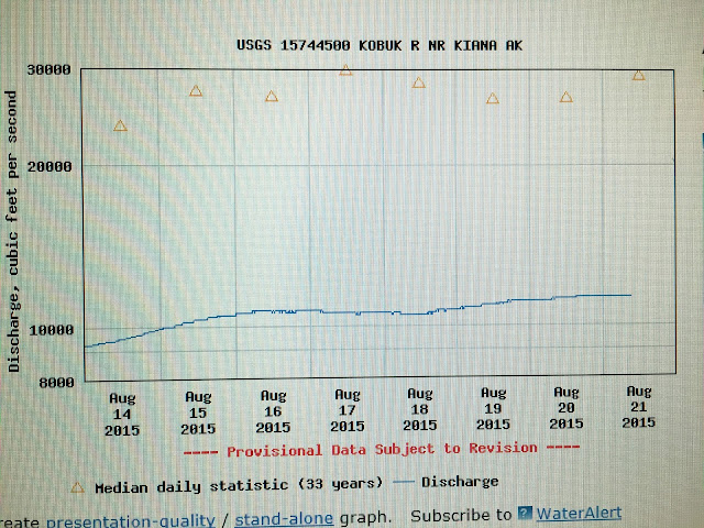
The Ambler school let us use their computer lab to check the stream gauge in Kiana. The river was running at ~12,000 cfs when it’s normally around 30,000 cfs! Flow, not slope, is what carries a boat downstream on the lower Kobuk; the river only drops six inches per mile.
The main road in Ambler. Plastic is easier to fly in than pavement.
On this section, we ate better than we do at home: Adventure Appetites’ reindeer sausage scramble, beef curry, chicken chipotle enchilada, fresh oranges, olives, cocoa nibs, mulberries, fancy salami, and smoked maple sardines!
We became very excited when we saw this 200 ft. tall bank.
I wanted to bring this home. The decision-making process took 45 minutes.
Why, yes, I'd like some sun-dried tomatoes with my olives and salami and cheese and crackers and chocolate!
Great Kobuk Sand Dunes

KIANA TO KOTZEBUE(58 miles via airplane)
We enjoyed aerial views of the Kotzebue Sound on the Bering Air flight to Kotzebue. The city, population 3,200, was gigantic compared to the villages we’d visited. We saw pavement for the first time in 32 days. We camped in someone’s yard. We were tired.

Our extra day at Walker Lake and the low river put us behind schedule. We flew from Kiana to Kotzebue.

Happy and tired, camping in someone's yard in Kotzebue.
HOME
Returning to civilization took considerable adjustment. Sarah woke up at our Eagle River cabin and briefly panicked because there was a roof over her head. “What is this?! Where are we?!” I took another week to transition before going back to work. She returned to hot and sunny Salt Lake City, where she complained about the 60-degree temperature change, criticized the impracticality of people’s clothing and footwear, and chose to walk nine miles round trip to school rather than take the free bus. 


Follow us on instagram

Brooks Range Traverse Gear List and Discussion

$
0
0
Download a gear list with post trip commentary here. Our favorite items were:

Sarah
  1. Patagonia Houdini Pants  -  favorite hiking pant
  2. Hyperlite Mountain Gear UltaMid 4 shelter  -  an ultralight palace
  3. Aloksak Opsak odor proof food bags  - effective and durable
Max
  1. ZPacks 10 degree Twin Quilt  -  best ultralight bag on the planet
  2. Tyvek tape  -  for attaching sleeping pads together; repairing pants, jackets, and the boat
  3. Patagonia Merino Air Hoody  -  the most comfortable cold weather baselayer
I was most disappointed by the:
  1. ZPacks Challenger rain jacket and pants (link to detailed review)
  2. Mesh backing on Hyperlite Mountain Gear packs' hip belt and shoulder straps. I've felt this way since I first used HMG packs in 2011 and have seen four friends come home with lesions on their shoulders and backs (Sarah still has scars). The material clogs with pine needles, sand, mud, and snow; eats through expensive merino wool baselayers; and prevents you from using the pack without a shirt. I talked to Mike about this in September. HMG is considering revising the design.
Stay tuned for reviews on
  • Alpacka Gnu packraft 
  • Patagonia Merino Air Hoody
  • Rethinking the synthetic jacket
This summer was so exceptionally dry we didn't need bug shirts. Nonetheless, Sarah enjoyed hiking in hers on warm days. I barely used mine.

Hyperlite Mountain Gear Floorless Bug Inset. Floorless was key; I can only image the $475 floor version being useful for car camping.

The Rab Xenon works fine, but we would have been better off with down jackets.

The Alpacka Gnu was PAINFUL!!

ZPacks Challenger Rain Jacket and Pants Review

$
0
0
The ZPacks Challenger Rain Jacket and Pants are widely regarded as the best ultralight rain gear available. This summer I tried the latest iteration on a five-week trip in the Brooks Range. Although their design and fabric are much improved since I first used them in 2012, I found them to be significantly less impressive than expected.

Sarah used the Challenger pants and a Patagonia M10 jacket. I used the Challenger pants and jacket.


Fabric
The fabric has an impressive tear resistance. Even with a lot of brush, we only had one puncture in one pant leg. The face fabric, however, delaminated (bubbles) in many large areas. Another serious flaw is the poor DWR; the face fabric wet out near instantly (the jacket and pants were brand new when we started), which reduces breathability to zero. Also quite uncomfortable: unlike 3-layer waterproof breathable fabrics, the inside of this material becomes very sticky. Rather than sliding over them, it caught on my shirt, fleece, and long underwear.

What could this fabric be good for? The top half of a climber style bivy sack. That's all I can think of. 

Construction
ZPacks' lamination leaves some adhesive exposed, or it becomes exposed after use, and this also catches on baselayers and fleeces, which restricts your body and pulls your clothes apart. The inside seams were covered with green from my fleece. Black bits from my long underwear were stuck on the of the pants. Even after being washed, the seams are still covered with fleecy bits! Bottom line: ZPacks' makes many very fine products (their Twinn Quilt is one of my favorite gear items ever), but their waterproof breathable construction quality is far from that which Gore-Tex requires from manufacturers. (Gore-Tex products require style approval and must be made in Gore-approved factories.)

Great Kobuk Sand Dunes, Kobuk Valley National Park
The face fabric delaminated significantly under the armpits, on the arms, the hood, and all over the legs.
Fit and features
I found the arm length to be several inches shorter than a normal men's medium. My fleece and baselayers stuck out beyond the end, which forced me to fold them back into a big clump that nonetheless got wet. The cuffs would benefit from being slightly wider, too.

Like on the previous version, the pattering on the jacket is quite poor at allowing you to raise your arms overhead. This, combined with the not helmet compatible hood, makes the jacket ill-suited to vertical endeavors.

The drawcord on the bottom of the pants frequently caught on branches. This should be moved inside the leg like is common on many climbing and skiing pants (see the design of the Arcteryx Alpha SV bib, for example).

The chest pocket works and is a welcome addition compared to previous versions. It would benefit from a zipper garage to prevent dripping water from entering the pocket.

The pants are the better product
Rain pants are used less frequently and have less of an impact on your comfort than a rain jacket. For many ultralight hikers, the drawbacks to the Challenger pants (low breathability due to the face fabric wetting out, poor ankle closure design) will be overcome by the weight savings. My pants only weigh 3.8 oz.!! Relative to the competition, I feel the Challenger pants perform better than the jacket.

Bottom line
I recommend the pants to ultralight hikers with the cash required to save a few ounces. I only recommend the jacket for short duration use on trips that are primarily on trail AND have a low probability of short duration rain. The jacket is suitable for dry places like the high sierra and desert southwest--where you carry it 95% of the time. For long trips, off trail travel, and use in wet climates I recommend a jacket with a better fabric and better construction.

Long-term best value rain jacket suggestions
I've used the below jackets extensively and highly recommend them.

The Patagonia M10 (8.8 oz in medium, h2no membrane, 15d face fabric) is arguably the best hardshell for backpacking; it's lightweight and functionally durable. Photo: Chris Simrell crossing the Elwah River, WA.


The Arcteryx Alpha FL (11.2 oz in medium, Gore-Tex Pro membrane, 40d face fabric) remains the best all-purpose hardshell and is tough enough for long-term use in abrasive environments, such as climbing, and when carrying a heavy pack. I wish I had brought this jacket to the Brooks Range and I wish Arcteryx made pants without side zips out of this material. Photo: On top of Mt. Huntington, AK.

Seldom Through Escalante

$
0
0
The original aim for Sarah’s fall break was frontcountry camping with day hikes, sport climbing, swimming, and sunshine—the opposite of bushwhacking in Alaska. After much deliberation and planning, however, we chose a 150-mile off-trail route through canyon country. The aim was to go down the Escalante River and up through Capitol Reef National Park in six days.

Unfortunately, the Escalante was filled with brush and the riverbanks were steeper than expected—up to 10 feet tall and, more often than not, close to vertical. We crossed the river approximately 180 times. It took five hard days to get through the canyon before we bailed out to the Coyote Gulch trailhead. We canceled on Capitol Reef—the part we were most excited about and had spent over forty hours developing the route—and hurried back to Salt Lake for a house!!

Our 80 mile Escalante hike (red) and the intended 75 mile link-up through Capitol Reef (orange)
Though the trip involved more hardship than desired, we were fortunate to see a very fine canyon landscape. Most impressive to me were:

(1) The effort to remove Russian olive from the watershed. We passed three crews of six ish people working in the upper canyon. They were cutting smaller trees into sections and girdling the larger trees, spraying the cut with poison, and letting the tree die standing. The problem with Russian olive, one young lad told us, is it holds the riverbank in place, which creates tall, steep banks that increase the speed of the river and destroy fish habitat. We saw stumps from previous crews throughout the upper two thirds of the canyon and sections of cut trees throughout the 76 miles we walked in the canyon. In some areas, floods piled the cut olive logs in four-foot high walls that we climbed over, and over, and over.


(2) The rock climbing potential was astonishing. Huge 1500-foot walls, splitter cracks, and perfect boulders graced the lower third of the canyon. We walked by one five-star highball problem that appeared V4. The start was a hand-heel match about five feet off the ground, then it moved through pockets and jugs to a three-foot throw from a rail to the top, close to twenty feet off a flat sandy landing. I tried to pull onto the start with my trail runners on, but felt far too weak from hiking.


(3) The difficulty of the terrain and vegetation for a dog. This trip was the first that Seldom, Sarah’s dog, carried his food in a pack. He’s an very capable outdoor dog—he makes 4th class scrambling look like a ride on an escalator, does 30-mile mountain bike rides, and finds his way home when we leave him up to 10-miles away. Swimming across the Escalante with a pack on (it weighed 15% of his body weight), charging through dense brush, walking through fields of sharp tumbleweed and cacti, and climbing up and sliding down the steep banks brutalized him. He developed large lesions under his arms from the wet, sandy pack rubbing on the inside of his front armpits (we carried his pack for the fifth day), and worse, he was so exhausted from the trip that it took four days of sleeping and eating in Salt Lake before he regained his usual spunk and personality. Next time, we’ll spend more time considering how vegetation will impact him, and try out the pack again to see if the problem was a poor fit, or sandy wetness.


Getting water from a tank at the Coyote Gulch trailhead before walking/hitching back to the car


Winter 2015 Roundup

$
0
0
My last few months have been filled by work, travel, and 10 nights in the backcountry. I spent 3-weeks in Utah in October, thirteen days in Idaho and New England in November, and just finished a three-week trip to Nebraska, Utah, and Washington. Here are some highlights.

Chugach mountains 40 minutes driving and 120 minutes walking from Anchorage. They make a wonderfully steep backyard.
I attempted a three-night ridge traverse, but bailed on the second day because the terrain required two ice tools and I foolishly thought I could make do with one. This was the first night’s bivy. The high wind and driving snow made for a good (uncomfortably wet) opportunity to test two new synthetic insulated jackets for BackpackingLight.com (reviews coming this spring).

Near the summit of Ptarmigan peak looking at Anchorage. I walked from my house along the ridge to this point in about 12 hours.
Day hikes on turnagain arm are hugely rewarding: the steep slope and low treeline make for fast, stunning views.


A Maine island as seen from a WWII bunker. I believe this has been Maine’s warmest winter ever recorded.
Nebraska prairie walks with the greatest prairie enthusiast.
Across the street from the greatest prairie enthusiast’s home in Raymond, Nebraska.
Ditto
Ditto
Outing with Sarah’s family
Bouldering with Chris and Molly in Gold Bar, Washington. T-shirts, blue skies, awesome granite, and in January!?

Backpacking Capitol Reef National Park with a dog

$
0
0
Dogs are prohibited from backcountry areas in national parks. I support this policy because most are poorly trained. If allowed in national parks, they would foul the “natural atmosphere” and have mild ecological implications. Despite my support for the policy, Sarah and I planned a 90-mile route into and through Capitol Reef National Park with her dog Seldom. We chose to violate the no dog policy because we felt Seldom would have no significant adverse implications to humans or the environment:
  • He has no negative social implications. He does not bark at people or dogs outside and rarely shows interest in other dogs. The only potential negative impact is on people’s perception of nature and "wilderness." That is, someone might become disturbed by seeing a typically urban pet in a location they believe to be wild. But, compared to the average backpacking dog, this is rare because we rarely hike on trails, rarely camp in established sites—we most commonly go to places without other people.
  • His environmental impact is equal to or less than a human’s for three reasons: (1) He doesn’t chase and therefore has little impact on wildlife. (We have a near perfect success rate at calling him back from moose, bears, mountain goats, deer, birds, etc; (2) The area of his paws is smaller than my feet—he crushes, for example, less cryptobiotic soil than I do; (3) Like ours, his poo can be buried.
I believe Seldom’s excellent behavior combined with our route selection and low impact camping practices make it reasonable for him to join us on certain trips through backcountry areas in some national parks. Capitol Reef being one of them.


The Route
We planned a 90-mile mostly off trail route from the Coyote Gulch trailhead to the Capitol Reef visitor’s center in Fruita—alongside, through, and on top of the reef. The original aim was to do this in October, but our 80-mile Escalante trip took longer than expected (we intended to combine them into one trip) so we rescheduled the reef for the first week in January. 

Hitching in blue, walking in pink.
Better than being sick in a warm house
I caught a cold when we were leaving Nebraska and Sarah felt like she was coming down with one. We went forward with the trip because, as Sarah said, “being sick in canyon country is better than being sick in a warm house in a warm bed in Salt Lake City.” Through we felt weak and tired, it was totally worth it; coughing up green phlegm in a gorgeous canyon was far more enjoyable than in my bed.

We covered the ~110 miles from our parked car to the start of the route with only six miles of walking—a lucky feat considering the rural roads and low season traffic. We rode with a Mormon family from Salt Lake, cabin owners from Salt Lake, California road trippers, a fourth generation local rancher, and California landscape photographers. The California road trippers asked us why Seldom didn’t have a pack, which made us realize that we left his pack and food in the car. Oops!

Wading through the unfrozen Escalante river with air temps in the 20’s was frigid. I carried Seldom on my pack across the open water, breaking through the ice on the banks, so he didn’t turn into a frozen fur ball. He loved it. Farther up, the river had three to four inches of ice in some places; we tiptoed across, sometimes dragging our packs behind in case we broke through.

Walking through Stevens Canyon was a blast. There are several areas the easiest route crossed slickrock benches in order to avoid pour overs. Great fun. The ice pools were also fun to walk on and we smashed them with big rocks to get drinking water.


The ice completely changed how we interacted with the canyon—rather than wading through pools, we slip and slid across them.


On the afternoon of the third day we bailed from our route in hopes of hitching on the Nottom-Bullfrog road back to our car. This decision was motivated by the snow, which had arrived in quantities that would have made our high, slickrock route unreasonably dangerous and much slower. We were also moving slower than normal, our bodies felt tired and achy from being sick, and I had a flight to catch in two days.

We exited east and walked to the road where we immediately caught a ride with some archeologists who were surveying BLM roads. They carried us out of their way for 15-20 minutes. Then we walked for several more hours into the darkness without seeing any other vehicles. The next morning we woke up at 4:00 AM to 3” of fresh snow and set off down the road (6” of snow) expecting to walk the remaining 30 miles to Highway 24, where we could hitch to our car. Remembering walking in the pre-dawn hours munching energy bars and watching color return to the landscape makes me smile. A friendly rancher from Utah Sandy Ranch picked us up and drove us the remaining distance back to our car. We walked about 16 miles by 11 AM and were darn tired—Sarah had a sore throat and I was still expelling green phlegm. We could see the happy exhaustion in each others faces.


$125 fine for Seldom
We took almost no care to hide Seldom from park employees: we parked in front of the visitor center’s main entrance and filled out a permit (during the process we had to lie about not having a dog and that person later saw us with Seldom—she knew we were breaking the rule). Further, when we returned to our car Sarah went into the visitor center where the person she lied to saw her and called in a ranger. We voluntarily showed the ranger our intended route with ~50 miles in the park, described how our actual route differed from the intended. 

Both the ranger and the visitor’s center employee described the rationale for the no dog policy. We refrained from arguing why Seldom’s impact was less than that of the average dog (or person?) and that grazing cattle in the park (much of the park appeared to be grazed) has a greater ecological impact and a causes a much greater reduction in people’s perception of “wilderness” than allowing the rare dog to accompany the rare backpacker. Instead, we accepted the fine as the cost hiking with a dog and as punishment for our lack of effort to avoid park employees.

Despite the sour ending, this was a lovely trip in stunning country. We are both excited to return to finish the reef scrambling and canyoneering route. Reflecting on the region in general, I suspect Coyote Gulch to Stevens Canyon to an exit on the Nottom-Bullfrog road is one of the best short trips (2-4 days) in the Southwest.

Ski Tracks, Ptarmigan Peak: route description and topo

$
0
0
Last Sunday, Cory Hinds and I climbed Ski Tracks, a 8-10 pitch mixed route on Ptarmigan Peak that's seven miles from my house. The route gets its name because ice (normally) forms in two parallel lines near the top of the north face and could appear like ski tracks. Cory drew a topo and typed up a route description, which I'm posting here because it's the only way for it to reach the public (he wrote it for the Alaska Mountaineering Club's monthly publication, which only reaches paying members).

We had a blast of a day. Biking in five ish miles on packed snow and climbing mostly easy mixed terrain with some snow slopes. The wind picked up in the afternoon and sent torrents of spindrift down on us. The last two pitches were the thinnest Cory has seen them (he's climbed the route five other times). We reached the summit at 3:30 PM, enjoyed some sunshine, splendid powder glissading, and bombed back to the truck on the bikes. This was the most diverse day trip I've done in the last several years--we had everything from fun and easy biking, frozen hands, vicious spindrift, a bit of post holing, and stunning view of countless mountains including Denali. What a great day.

Ski Tracks Topo


Pitch 1

We found a little bit of ice. And had great views--Denali is the distant bump on the right.


Summit view--mountains beyond mountains!


Cory's Route Description
Pitch 1:  Start at the first major bulge of rock on the right side of the north couloir, at the base of an obvious weakness in the mountain trending up to the right, approximately 500 feet from the bottom of the couloir and ~1 hr hike from the Powerline.  Kick steps up a short slot, clipping a fixed pin on the right when it steepens.  Climb through and around blocks and steps with good jugs and frozen turf, passing a fixed spectre on the right (crux #1).  Continue straight up to a set of slings around a block.  Clip the slings with some long runners and traverse right another 30 meters or so to another block with slings on the shoulder (low angle but run out).

Pitch 2:  Ascend the easy snow ramp, placing protection in the rock wall on the left.   Stop at a left-trending ramp before reaching the ridge crest, and before reaching a rock wall with black streaks.   We found a fixed tricam at the anchor, a few steps up the ramp.   Recommend simul-climbing the ramp to the anchor.   

Pitch 3:  Climb the left trending ramp and turn the corner to the right up into a chimney.  Stem past a chock stone then stem up and exit left (crux #2) at the top of the chimney.  Traverse left 10 m or so after exiting the chimney, and up around a broad ridge to a snow field.   Climb the snow field to a short face where you will find a fixed anchor.

Pitch 4:  Walk right up a snow ramp into a major amphitheater with a steep rock wall at the back.   There are various options here.  Go left to the ice if the ice is in good shape.   If it looks too thin (which it often is), descend back to the center of the amphitheater and kick steps up the snow ramp on the right side of the amphitheater and set a belay left of an obvious weakness in the rock wall.  

Pitch 5:  Climb through the weakness, finding good rock protection and exciting moves with good foot steps and some frozen turf (crux #3).  At the top of the short wall (40 m or so), move left and up across a snow ramp to first possible belay anchor in the rock wall above.

Pitch 6:   Move left and around a short corner.  If ice to the left is good, climb the steep step.  If it is rotten, climb lower angle rock and turf to the right of the ice, up through an awkward squeeze slot.  Then ascend left across some lower angle ice and up into the right Ski Track gully.  Belay at a crack at the top end of the first rock wall on the left side of the gully.   

Pitch 7:  Climb straight up, over a short steep ice step and through a lower angled snow field.  Belay at base of next steep pitch.

Pitch 8:  Climb up the steepening couloir, typically filled with ice.  This is moderate ice climbing, maybe grade 3+ or 4-.   Near the top of the couloir, the route steepens and the ice sometimes thins (crux #4).  If the ice is too thin, look for options of rock protection in the left wall.  In low ice years (like January 2016), this can make things very exciting, with a long runout. Top out around a final small boulder and look for a fixed spectre in the next crack on the left.   Your partner can walk up onto safe ground and belay you up.   

Walk up to the right up an obvious ramp and top out on the ridge then turn left and walk to the summit.   Enjoy the view, then hike off the backside, down through Ptarmigan Pass, and back down to Powerline.

MYOG: Ultralight Modular Dog Bed

$
0
0
The best value products are versatile and durable. With this in mind, I built Seldom an ultralight modular dog bed that aims to excel at home and on weight conscious backcountry trips in colder temperatures. It uses the best outdoor materials available and weighs 4.2 - 16.1 oz., depending on the configuration. Seldom has used it for a 5-day backpacking trip in January and indoors and out everyday for the subsequent six weeks. Here I report on the motivation, design, and performance.

The backcountry configuration: closed cell foam pad with a cuben fiber and Climashield Apex insulated blanket. Utah canyon country, 20 degrees.


The urban configuration: closed cell foam pad and one of two fleece toppers. He was tied to a fence under an awning for 6 hours, temps in the upper 30 degrees. 
Motivation
Last summer Sarah and I learned that, unfortunately, Seldom gets cold when he sleeps outside when it’s in the 50’s and raining. We suspected he would get even colder when sleeping on snow inside a floorless shelter. Sarah has chosen not to buy a traditional dog bed because: (1) around the house, he can lay on other things like rugs; (2) it adds complexity to life—another thing to clean and move with; (3) they’re ugly as hell, often smell bad, and take up valuable space inside a living area; (4) existing options, such as Ruffwear’s backcountry model, (designed to be used inside a tent with a floor) would perform poorly for for ultralight travel in wet conditions, are relatively heavy, and are not aesthetically pleasing for use indoors.

Design
Objectives:
  • Lightweight and compact – easy for us and him to carry
  • Warm enough for winter while sleeping on snow
  • Comfortable for indoor use
  • Aesthetically pleasing
  • Easy to clean 
The bed has three parts that attach with velcro:

1.  Closed cell foam bottom, 4.9 oz.
I used 1/4” Gossamer Gear Thinlight for the bottom because, unlike Therm-a-Rest closed cell pads, it’s flat (rolls up smaller) and can be purchased in widths greater than 20”, thereby avoiding 

      2.  Insulated blanket, 4.2 oz.
      I chose 3.6 ounce per square yard (osy) Climashield Apex synthetic high-loft insulation because synthetic insulation manages moisture better than goose down, and this model's continuous filaments make it more durable than most (or all) other synthetic insulations. To make it waterproof and easy to clean, I chose 1.0 osy cuben fiber, which is waterproof, light, durable enough for many years of use, and easy to repair. Though we haven’t washed it yet, the blanket should be handle a washing machine and drying on low heat.

     3.  Two fleece toppers, 7 oz. each
     Sarah picked out two fleece patterns for the toppers: moose and bison. (Seldom was born on a bison ranch in South Dakota.) We chose two because we can toss the dirty one in the wash and immediately stick on the other one, enjoying both a new look and the instant gratification of a clean bed.

The aim is to use the pad and blanket in winter and when snow camping (9.1 oz. total), and the blanket alone (4.2 oz.) on cold, snowless trips in spring and fall. At home, he uses the pad and fleece (11.9 oz. total). The blanket compresses to the size of an orange and is easy for Seldom to carry in his pack. The pad, however, is large enough that we need to carry it.

Testing the cut fabrics. Does it fit? Does he like it?

Curled up and cozy on a stormy night in southern Utah. 
Performance Review
Finally, I have something that’s mine. People and all the other dogs I see have so many things. Things, things, things! Except for my leash, which Max made, and my tennis balls, this is my first and only thing. I love it. It’s my space when I wait for them, my space for retreating when the girls are blasting their music and doing girly things, and it’s a lot softer and warmer than the bare wood floor. Max made it for our adventures and it kept me warm in the snowy desert last month. He neglected to consider that I like to get up in the middle of the night, at least once, and can’t tuck myself back under the blanket. I want him to add velcro to all four sides of the pad so the fleece stays attached better. (I use the pad everyday at home; it’s worth the extra 0.5 oz. weight penalty. What a stupidlight choice, Max!) He also only added velcro to two sides of the blanket; I want him to add it to a third so keeps me cozier like their sleeping bags. Finally, the blanket should be a few paws wider for Alaska winters—so it drapes down and closes me in completely. That’s my feedback for him. And I’ve gotta say, I’m a little envious of the dogs that have huge cushy beds at home. WOOF those are nice. But mine was made by hand, by people that love, me for me. Not by people in China, for any old dog, by people who don’t love me. So I'm proud to use it. One last thing: Sarah and I go to coffee shops a lot and I’ve enjoyed sitting outside watching folks from my bed, which she sets in the snow. She attaches it to her pack like others do yoga mats and we bike around town. My bed on her pack :)

Chillin' while we cook dinner.
Future Updates
The design works very well at home and around town. I’m going to follow Seldom’s suggestions (larger blanket, more velcro to secure the pad to the blanket) to make the blanket warmer. This should make it suitable for cold winter use.

I've pondered a groundcloth with a lighter cuben fiber that would attach to the blanket--creating a sleeping bag with an uninsulated bottom. This could go on top of our backpacks and other things that provide insulation from the ground, and would allow us to leave the foam pad at home, which would save ~4 oz. and lots of space. I doubt I'll move forward with this because the larger blanket should cover him well and he can lay on a backpack for insulation from the ground.

Tempted by the lack of midnight maintenance--tucking Seldom back under the blanket if he stands up--I’ve considered making a synthetic insulated jacket, but have decided against it because it wouldn't be as warm for its weight and we wouldn't have the benefit of a dedicated space for him in a shelter. If he comes out of the blanket, and gets cold, he'll let us know and we'll tuck him back under.

Stretching as Sarah finishes a coffee shop work session.

Salmon and Wild Rice Cake Recipe

$
0
0
Light, fresh, bursting with a flavor, and wonderfully healthy, this is one of my all-time favorite meals. They're Christmas, wedding, and special occasion good. Damn good. Making them takes two to three hours, but the investment is well worth it. I recommend doubling the recipe and so you can freeze the extras for a future meal.

Makes 12-18 cakes. Serves four. Pair with a salad. If you have a hungry crowd, cook more wild rice and serve that as a side.


FISH CAKES
5 C  baked wild Alaska sockeye salmon (roughly two pounds boned and flaked)
1 C  cooked wild rice (~1/3 C uncooked)
1.5 C  fresh bread crumbs (ideally rye, gluten free works fine if that's you're thing)
1 small red onion, minced
¼ C fresh dill, minced
2 T sauerkraut, minced
2 T capers, drained
1.5 T horseradish
2 T fresh lemon juice
2 large eggs, lightly beaten
½ C greek yogurt
½ C unbleached all-purpose flour
1 t salt
1 t freshly ground pepper
1 t paprika
salt and freshly ground pepper, to taste
3 T unsalted butter


DILL-MUSTARD SAUCE
2.5 T grainy mustard
2.5 T money mustard
1 T white wine vinegar
1 T honey
½ C olive oil
½ C fresh dill, minced
 
Optional: Preparing the sauce a day in advance creates the best flavor. If making extra to freeze, place tablespoon sized amounts of sauce onto plastic wrap or waxed paper.

INSTRUCTIONS
  1. Bake the salmon with a very light rub of olive oil, salt, and pepper. Cook the rice. Prepare the other ingredients while the fish is cooking and cooling (about 10 minutes). Flake and remove the bones from the salmon with your hands.
  2. Combine the following in a large bowl: salmon, wild rice, bread crumbs, onion, dill, capers, horseradish, sauerkraut, lemon juice. Mix well. Add the beaten eggs and yogurt to bind the mixture.
  3. Add the flour, salt, pepper, and paprika in shallow dish. Form 3-4 inch diameter patties with your hands. Lightly coat both sides with the flour mixture. Place on a flat tray in a single layer. Makes 12-18 cakes depending on size.
  4. Sauce: whisk the mustards, vinegar, and honey. Whisk in the olive oil while pouring in a thin, steady stream. Stir in the dill. Refrigerate until serving. 
  5. Cook the cakes: melt 1 T butter in a large skillet over medium heat. Cook each cake for 4-5 minutes per side, or until golden brown, flipping once. Add more butter when necessary. Keep the cooked salmon cakes warm in a low oven while cooking the rest. Serve 2-3 cakes per person with 1T of sauce on top.

Ruth Gorgeous: multi-sport in the Alaska Range

$
0
0
In mid-April, Eric Shaw and I flew into the Ruth Gorge, hauled a luxurious basecamp up to the Root Canal, climbed ~1.75 routes on Moose’s Tooth, and skied and floated back to the car in Talkeetna. Thirteen-days. In three acts:

Mt. Dickey. This face is 5,000 ft. tall.
Our route

ACT I
“Old-school” said Caitlin Palmer, co-owner of Alaska Mountaineering School, when she unlocked their gear store for us in the morning. In the afternoon we found out what that meant: carrying 80 - 90 lb. of gear per person up a 3,000 ft. ice fall was really hard. We took a gully that bypassed the most cracked-up section and had to haul, as in big wall style, two packs each up a 30 ft. mixed pitch that’s probably covered in snow at other times. We made several loads, caching things here and there. Bedtime at our basecamp came around 2:00 AM on the second day. Thus, getting to the base of the routes was the hardest part of the trip.

Modern practice for climbing this face on Moose’s Tooth is to fly into the root canal when there’s a good weather window, climb the next day, and fly out the following day. Or perhaps stay longer to admire the views.

In retrospect, we should have gone up to the root canal with a light setup and a few days of food. But it was nice to eat pancakes and bacon like everyone else.
Eric, carrying loads up to the root canal. Later this day we enjoyed a 10 PM ski down to our cache: four minutes of turns in the evening light, between huge granite walls.


Moose's Tooth summit selfie
Eric descending Ham and Eggs
Afternoon turns!!

ACT II
A baseball-sized chunk of ice fell 200 feet and hit me in the face when we were ~1500 feet up Shaken, Not Stirred. It was an inch from breaking my nose. I was bleeding from two cuts and lost all motivation to continue.

The crux was a mess of overhanging sugar snow. Eric went up some, found unprotectable rotten ice underneath, and we bailed. Ham and Eggs was the same way two days prior, but the climbing was easier so we went anyway.


Descending Shaken, not Stirred.

Our basecamp. We brought a pyramid tarp but never put it up.


Pancakes and bacon!


ACT III
The ski and float out were marvelous. It took three days and half of one was spent stationary, waiting for a storm to clear. My favorite part was weaving between granite boulders on the edge of the Ruth. Eight miles of gorgeous rocks and views. The boulders looked great for climbing. I imagined a fly-in alpine bouldering session some future summer.

I broke a ski tip falling on the hard crust among the boulders. Fortunately, it still worked okay for the remaining ten miles over the pass in the Tokoshas and down to the river.

Eric’s ski gear was archaic. He had really heavy four-buckle boots that didn’t bend backward. His skis were twin-tipped from high school. The bindings were—I don’t know the technical term—huge, clunky plastic contraptions. Yet he could keep up a good pace.

He’s also a great Class V whitewater paddler and an expedition canoe instructor. “There are 20 something different canoe strokes,” he told me. Sharing the Gnu with him was similar to what I imagine sitting in the passenger seat while a pro racecar driver takes you rallying in your own car to be like.

The final moment: Having no better alternative at the Talkeetna Air Taxi bunkhouse, we both climbed onto a one-person platform and shared our two-person sleeping bag, which was soaking wet from the previous rainy night.
Waiting for the storm to clear so we could descend the backside of Dickey. We shivered under this tarp for a few hours then put the tent up again. Eventually, the sun came out and we were skiing in baselayers.

The red dots show our route along the Ruth and up to the Tokoshas. As seen from the summit of Moose's Tooth


Wet and Wild: Baranof Island Traverse

$
0
0
Baranof Island likely has the highest density brown bear population in the world and the highest island-based peak in the US outside of the Aleutians and Hawaii. It’s 100 miles long by 30 wide, has 14 miles of roads, and is home to 9,000 people.

Baranof island: nary a flat spot!

Most of the accessible valleys in southeast Alaska were clearcut long ago. I followed an old road now washed out, with a narrow game trail weaving through young trees, passing stumps of giants turned furniture, decking, and musical instruments.  

Ever since I learned I might end up in Sitka for part of the summer, I thought of crossing the island lengthwise. It’d be around 120 miles with 120,000 ft. elevation change—a ridge traverse with miles of glaciers clinging to the sides of rocky peaks (lots of class IV and V scrambling) with rainforests below.

There’s nothing I love more than kneeling down to drink out of seeps, creeks, and puddles. All the better when these beauties guard the pool.

I guessed it’d be the hardest hiking trip I’ve ever attempted. Though more mentally and physically challenging, going alone was something I wanted, in part because the longest solo backcountry trip I’ve done was three days.

Water taxi with Captain Xander!
Prep
I talked with all of the people who have done significant backcountry trips here. All three of them. I learned that no one has come close to traversing the island lengthwise in one go. One party has hiked from Sitka to Port Alexander in 21 nights over four summers. One in that party, Dan Evans, told me this would be the worst possible time—earlier is better because there’s more snow and the brush (salmon berries, grasses, devil’s club) isn’t 10 ft tall. Mike MacFerrin made a wonderfully squiggly route from Sitka to Port Alexander, paddling perhaps 75% in a packraft, over 18 days. Steve Reifesntuhl, the most experienced wilderness traveler in Sitka, with decades of impressive ultra-endurance feats under his belt and unsurpassed local knowledge, confirmed my suspicion that it’d be best to stay high as much as possible.

When it’s not raining, the clouds are so dense it’s effectively raining. This is not a grassland, but the top of a 3,000 ft grass mountain. 

I was really intimidated. Partly because no one had done it before, partly because I knew it’d be really hard for me, and partly because there was a lot of unknown technical terrain, and notoriously bad weather.

I went to a deep, dark, cold, murky pool that was labeled “hot springs” on the topo. That evening, several miles away, I dipped my cook pot into the pond behind the tarp and found it to be a pleasant 66 degrees when the air temp was 50! Then I cooked dinner with it. 

I had no idea what the ridges might bring and couldn’t see ahead pick a route. Here’s one sharp section. Sometimes it’s nice not knowing what’s below.

I looked at topos for a long time, guessed which ridges might be easier, and packed up food. I set off intending to try the northern section of the island and keep going if the going was good.

The infamous Baranof Island cloud dragon. It can be bluebird above 4,000 ft. and raining below. 

Off
I spent a day walking the docks at all of the harbors trying to catch a ride with fishermen—they, being experts of the maritime environ, were filled with preposterous bear stories and gun recommendations—before getting a “good guy discount” (perhaps $400 off) for the 3 hour trip to the north side of the island. We saw a few whales, 20 some otters, and too many eagles as we cut through the dense fog. I was all giddy with excitement and uncertainty.

Up to about 2,000 ft., the island is covered in high bush blueberries.

I was trying to reframe the rain, fog, where am I!? as a patient process of discovery. 

Eventually, I entered the island’s most technical 20 miles of ridgeline and chose to bail because of the solid week of rain in the forecast. Continuing would have been a fantastic mountaineering experience (along a ridge that no one has likely traveled), but to do it safely and enjoyably, I’d need decent weather. Having a partner and a rope would be nice, too.

Generations of bear follow in each other’s footsteps, especially along the low ridges. Occasionally, I’d follow for fun.

I made it 17 miles by 11 PM the third night, through the most challenging and scary bushwhacking and vegetated downclimbing of my life. It took two hours to descend about 500 ft, which was so unpleasant I don't want to talk about it.

In total, I covered 37 miles with 19,000 ft elevation gain over three days—roughly equivalent to a third of the island. I was plum exhausted.

This is one of the peaks I scrambled over with zero visibility. In the morning, I got a 20-minute glimpse of it.
I learned:

  • It’s critically important to stay on the ridge
  • It’s orders or magnitude harder and less fun when you can’t see more than a few hundred feet
  • This place is SO WET and cloudy
  • Temperate rainforests continue to be my favorite forest. Their immense quiet and luscious greenery are unparalleled

Might I try it again?
Perhaps if someone else was interested in joining me.

The Best Ultralight Tent Shelter: Hyperlite Mountain Gear UltaMid 4 Review

$
0
0
After testing close to 70 different tents of all types for outdoorgearlab.com, I kept only four. Of those, I use the Hyperlite Mountain Gear UltaMid 4 most frequently. I think it's the best all-purpose ultralight tent on the planet. Since their release in summer 2013, I’ve used it, and the UltaMid 2, close to 100 days. If I were to have one tent for everything, I’d choose the UltaMid 4. It’s very expensive, but the low weight, tremendous versatility, unmatched comfort, and long-term durability make the cost worthwhile. After using both sizes I'm confident it's worth the extra $155 and four ounces for the UltaMid 4.

Since 2013, I've used my UltaMid with 23 friends and family members! So many great memories!

Motivation for this review

I wrote a review for the UltaMid for outdoorgearlab in 2013. Unfortunately, their current ultralight shelter comparison excluded it from testing. My motivation for taking ten hours to create this review comes in part from the lack of quality available reviews, part from my realization that I'm willing to spend $850 to replace it, and part from Hyperlite's affiliate program. If you find this review useful and click through to buy the shelter, I'll receive a small portion of the sale. I think this is one of Hyperlite's best products, but I'm not biased toward their products in general; I think some have yet to mature.

Pros: Bombproof four-season performance, incredibly comfortable for four people, remarkably light and compact, made in Maine with materials made primarily in Arizona.

Cons: $850, unsupportive vent awning, the vent should have velcro around the entire perimeter, a buckle would be better than a snap to relieve stress at the bottom of the zipper.


Key Specs
9.25’ x 9.25’ x 6.25’ tall
22-24 oz. with guyline and stuff sack

Hyperlite Moutain Gear UltaMid 4 ultralight backpacking tent shelter tarp lightweight
The Hyperlite Mountain Gear UltaMid 4 is the best all-purpose tent on the planet. Here, Sarah Brey brushes her teeth on a beautiful night in the Brooks Range, Alaska.

Cut from The Best Fabric
Dyneema Composite Fabric (formerly cuben fiber) is the best material for tents. Its tear strength is many times that of the best silicone coated nylons (including those used by Hilleberg), it’s incredibly lightweight, and it does not stretch or absorb water. These attributes create a very tight pitch that’s not possible with other fabrics. Super-reinforced seams also allow it to tolerate much higher forces than silnylon tents. This means that it’s less likely to rip when heavily loaded with snow. The only drawbacks to DCF are its lower melting point and lower abrasion resistance. In a pyramid tarp, neither of these are significant limitations because you can cook in the center, far away from the walls, and abrasion resistance is trivial because the shelter doesn’t contact the ground.

The Most Versatile Design
Below, I argue the UltaMid 4 is the best pyramid tarp on the market. The only exception is for solo travel, which it’s unnecessarily large for. If you do a lot of solo travel in very exposed areas, you can save 10 or more ounces by getting a one-person pyramid tarp from Mountain Laurel Designs or Locus Gear ($450+). However, I feel an 8.5 oz flat tarp ($310) is a better option for most people, including myself, because it’s even lighter, more versatile, also works well with two people, and you can mitigate the vulnerability of the three-sided pitch by choosing protected campsites. 


What About Two-Pole Pyramids!?

Lots of companies make pyramids that pitch with two poles. I’ve used the ZPacks Hexamid and Duplex and models from Six Moon Designs, GoLite, Black Diamond, and Mountain Laurel Designs. These can be lighter than the UltaMid 4, but I feel their reduced weather resistance and versatility isn’t worth the tradeoff. For example, the ZPacks Duplex has built-in bug protection and weighs 21 ounces, but it’s entirely inappropriate for winter, the design is much more fragile (the bug netting ripped on a corner seam in mine and it uses a less durable DCF fabric), and it’s much harder to setup in uneven and cramped sites. The Duplex is the best option for very buggy summer backpacking, but that's all it good at. Through testing over 400 outdoor gear products, I've learned that the best gear is versatile and durable. Two-pole pyramids with sewn-in bug protection are neither. If it’s buggy and saving weight matters most, I use a flat tarp (far more versatile and durable) and put a shirt over my face.

ZPacks Duplex ultralight backpacking tent shelter
Two-pole pyramids like the ZPacks Duplex, shown here in Denali National Park, southwest Colorado, and Olympic National Park, aren't suitable for winter use, are much harder to pitch in challenging sites, are less durable, and those with sewn-in bug netting and floors greatly reduce versatility. The UltaMid is well worth the additional weight and cost.

Max Neale cooking dinner in the Hyperlite Moutain Gear UltaMid 4 ultralight backpacking tent shelter tarp
Max cooking dinner in the UltaMid 4.  85 square feet of floor space is great for digging bench seats, a refrigerator, and a plush kitchen.

TESTING AND ANALYSIS

Weather Resistance
Single-pole pyramid shelters are the most weather resistant type of tent and are the proven best choice for wilderness travelers worldwide. They’re enclosed on four sides, offer bomber protection from high winds and snow, and trap enough air to keep you much warmer than open tarps.

I’ve used the UltaMid 4 as a cook tent for a couple of climbing expeditions and have found it much stronger and more comfortable than the competition. The most popular budget pyramid, the Black Diamond Mega Light, lacks mid-panel tieouts and its already stale design hasn’t been updated in at least six years—it doesn’t even compare to the UltaMid. For example, at a Mt. Huntington basecamp, my UltaMid stood up straight in a moderate storm while other people's Mega Lights were getting hammered. See the photo below. I’ve also used the UltaMid with two 40-year veteran Alaska mountaineers and they were hugely impressed--they raved about it (and I taught them about the material and design) for hours.

Can you use the UltaMid as your only tent on a worst conditions winter glacier expedition?


It depends on the commitment factor and the probability of big storms. I'd take the UltaMid for shorter trips with a better forecast and the Hilleberg Nammatj 2 for longer trips with a greater probability of big storms. In April, I did a two-week climb-ski-packraft trip in the Alaska Range and the UltaMid would have been better for the three-day ski/float out than the cramped, condensation nightmare bivy tent we brought. 


When camping on snow and expecting snow overnight, I like to pack up to a foot of snow around the inside of the UltaMid to support the edges. This helps snow slide down and off the walls rather than down and onto the bottom.

How well does it do in sand storms?


Compared to a fully enclosed four-season tent with solid interior walls, not well. But sand storms are rare, usually only last part of the night, and planning ahead to find protected campsites helps a lot. If the wind is blowing in tons of sand, in the desert or in a large river corridor, I've used the ground cloth to seal the windward wall. Worst case, you need to tuck into your sleeping bag. This is a worthwhile tradeoff: a few hours of windy sand every month of hiking (perhaps?) is fine when the shelter makes you vastly more comfortable for the hundreds of other hours spent traveling and sleeping.

Hyperlite Moutain Gear UltaMid 4 ultralight backpacking tent
Single pole pyramid shelters offer the greatest performance for four-season use. 
Hyperlite Moutain Gear UltaMid 4
At just 24 oz with my guyline setup, the UltaMid 4 makes a basecamp vastly more comfortable. Zeb and I agreed the largest gear mistake we made on our Cassin ascent was not bringing the UltaMid for the nearly three weeks of acclimatizing and waiting on the West Buttress.
Black Diamond Mega Light pyramids were hammered by a moderate storm while the UltaMid (shown in the same camp in the above photo) stood upright and unphased. Mt Huntington, Alaska.

How does it do in torrential rain?
Excellent. As with all tents, the main challenge with torrential rain is splashback--when water running off the sides of the tent bounces up and under the edge. The best way to address this is prevention: choose a campsite with a softer, absorbent surface (and one where water won’t pool). Last summer, I used the UltaMid on it trip where it rained 11 consecutive days. We mostly camped on gravel bars, which drain well but have a lot of splashback. There, the UltaMid’s large interior allowed us to move away from the edges to avoid the splashback. If the rain is incredibly violent and I’m in a bad campsite, I’ll use part of the ground sheet and backpacks to seal the walls around us. A deep bathtub floor would be more comfortable, but I experience bad splashback so infrequently I’d never want to carry it.

Unlike some mids, the UltaMid doesn’t have a flap over the watertight zipper. I criticized the shelter for this in my 2013 gearlab review and Tom Turiano, a Hyperlite Ambassador who got one of the first mids, commented that he just got off a trip with torrential rain and the zipper was indeed watertight. Over the years, this has been proven to be true through extensive use all over the world. The zipper on my mid has likely seen more wear than most. Sometimes, when it’s raining very hard, I’ll see a small bead of water form along the zipper, roll down, and drop off near the bottom. Initially, I was upset by this, but after close observation, I’m confident the droplets fall off at the bottom--not on us. Of course, this wouldn’t happen if there was a flap over the zipper, but a flap would rattle in high wind even with snap closures in the middle and bottom, and it’d be a huge hassle to close them. Thus, I think Hyperlite made a good choice with the zipper. In ten years from now, when the zipper has truly been tested by time, we’ll know for sure


Room for improvement?
The UltaMid has a metal snap at the base of the zipper that relieves stress on the zipper. This works fine, but it easily fills with sand and snow. Though it’s not as crushproof, I believe a plastic clip would be a better choice here—that’s what almost all four-season tents use.

Comfort
Most ultralight tents are cramped. The UltaMid is not only spacious but the light that comes in through the white walls make for a very pleasant environment.

Again, the extra four ounces and $155 increase over the UltaMid 2 is absolutely worth the extra comfort and versatility. The interior space (9.25’ x 9.25’ x 6.25’ tall) is mighty comfortable for four people and palatial for two. I’ve used it car camping with four people at least five times and love it. There’s even enough space to fit four people and a smaller dog (Sarah's is 40 lb). It’s so much fun to have family and friends in the same tent. I’ve also used it to cover a large picnic table, which made a wonderful group shelter for eight people! We hung a lantern inside and played cards until late at night while the rain poured down and in the morning we cooked breakfast and while the rain continued.

With two people, we almost always offset the pole to create more space in the center of the shelter. For example, if we’re sleeping in the back, we’ll put the pole off to one side. This creates internal vestibule space for backpacks and for cooking. It’s also very nice when removing soaking wet clothes: we’ll lay out the ground cloth and pads on one side, take off all of our clothes and sit on the pads to put on dry sleeping clothes. This isn’t possible with smaller pyramids.

Bug protection and flooring
After hiking for a while, I learned that a bathtub floor is unnecessary. Modular accessories allow us to optimize a tent for a specific environment.

Groundcloth
I usually bring a 72” x 90” polycro ground cloth ($9, 3.6 oz). These last for about a month before they tear and require taping. If you’re going on a multi-month trip where getting a replacement would be impossible, it might be worth getting one from a tough DCF fabric (around $100) or Tyvek ($10 and 85% heavier). ZPacks appears to be the best source for those.

Bug Insert
Most of the time, I don’t bring anything for bug protection. The UltaMid's enclosed walls do a remarkable job at blocking flying insects, If it's buggier than expected, I’ll intentionally pitch the shelter in a more exposed area. If it’s extremely buggy, I’ll bring Hyperlite’s floorless mesh insert ($160, 16 oz.), which works very well. If you're considering buying the UltaMid, I recommend using it for a while to see if you need the bug protection. Most likely, you won't. We often pack our fears; there's no need to get Hyperlite's bathtub floor insert.

Water Resistant Bivy Sacks
I've tested water resistant bivy sacks from Ruta Locura, Mountain Laurel Designs, and Katabatic Gear. The only time I use one is under a flat tarp when it's very buggy. I've been tempted by Mountain Laurel Designs' two-person water resistant bivy because it could save around 10 oz. compared to a ground cloth and a bug insert in the UltaMid, but I'm not sure it's worth it. When it's really buggy--when you need protection--it's great to have some space to escape. A bivy only provides an escape when you're horizontal, sealed up in the bivy. I might spring for the two-person bug bivy if doing another multi-week, two-person trip in the Arctic and we were trying to go as fast and light as possible. 

Hyperlite Moutain Gear UltaMid 4 ultralight backpacking tent
The UltaMid 4 is a fantastic shelter for mountaineering and ski touring. Shown here on a late-April trip into the Western Chugach mountains, Alaska. 

inside the Hyperlite Moutain Gear UltaMid 4 ultralight backpacking tent
Four people and a dog fit comfortably in the UltaMid 4. Shown on a family camping trip with the floorless bug insert.

Hyperlite Moutain Gear UltaMid 4 ultralight backpacking tent
Hyperlite's floorless bug insert is great when it's extremely buggy. In the vast majority of places the shelter's walls and strategic, i.e. exposed, campsite selection make owning one unnecessary. 


Hyperlite Moutain Gear UltaMid 4 ultralight backpacking tent bug insect insert
The floorless bug insert can be pitched by itself on calm, good weather nights. Having the insert with us, we opted for views in a soggy meadow rather than a bug-free site in the forest. Chugach mountains, Alaska.
Versatility
The UltaMid 4 is supremely versatile in the sense that it can be used for a huge number of activities with a variety of people. The ability to use it for backpacking, ski touring, expedition mountaineering and car camping is a huge advantage. You can literally own one tent for everything. (If you do a lot of solo trips, it’s probably worth getting Hyperlite’s square flat tarp or perhaps a one-person pyramid tent.)

My favorite story that showcases the UltaMid's versatility is from Brad Meiklejohn, head of the American Packrafting Association. He used the UltaMid 4 on a trip with three people that ended with a 15 ish mile flatwater lake crossing. They rafted their boats together, attached the mid to their paddles, and used it as a sail to zip across the lake at something like 8 miles per hour! Later, Brad told me that he did the same thing on a trip last summer down Alaska's Lost Coast--this time across a large bay. 

Ease of Setup
I find pyramids very easy to pitch. Tie two trekking poles together with a six-foot section of 1-2 mm cord, stake out the corners, insert the poles, close the door, extend the poles, exit, and adjust the position and tension of the stakes.

Hyperlite Moutain Gear UltaMid 4 trekking pole pitch
Tie two trekking poles together to pitch the shelter. This amount of overlap is good for most situations. Add more for high winds.
Since the shelter can’t adapt to terrain like a flat tarp, the only setup challenge is finding a site spacious enough to pitch it. This can be hard on rocky, steep mountains, but is made much easier by planning ahead a few hours by identifying possible flatter areas on a topo. In winter, just dig into the snow and make a platform.

Hyperlite Moutain Gear UltaMid 4 ultralight backpacking tent
Finding a large site is the only challenge to pitching the UltaMid 4. Traveling as a group of three in early March in Bears Ears, Utah, we stumbled around for 20 minutes in the dark before finding this opening in the brush. 
I usually bring four three-foot loops of cord to girth-hitch the corner tieouts to large rocks and logs. If I expect consistently challenging pitching conditions, I’ll bring extra loops.

After testing almost every stake on the market, I find that eight eight-inch Easton Nano Nail stakes work best with the UltaMid. With a large shelter like this, it’s important to have a reliable connection to the ground. (Most tent failures are caused by tieout failures that allow wind to catch a tent and excessively stress seams and zippers.) I’ve found these to be 100% reliable over many years of use in virtually all conditions. Naturally, there are some environments, like the desert southwest, that make it easy to travel without stakes. Generally, though, I bring stakes.

Weight
With extra guyline and the stuff sack, my UltaMid 4 weighs 23.9 oz. This is incredibly light for the amount of weather protection, comfort, and versatility it provides. If you’re traveling with two people, 12 oz. per person for a palace is amazing! 6 oz. per person with four people—incredible!

I’ve experimented with a variety of guyline setups and have settled on the following: I leave the stock guyline in the linelocs for the perimeter, year-round. In the summer, I replace all of the above-ground-level lines with long lengths of 1.25 mm dyneema cord. In the winter, I swap those lines with 2.3 mm reflective line (available at the previous link) and add MSR CamRing tensioners to each of the four corner mid-panel tieouts. The CamRings make it a lot easier to pitch with gloves on. I find the reflective cord to be nice when pitching the tent in the dark and it also makes it easier to find the tent at night.

Hyperlite Moutain Gear UltaMid 4 ultralight backpacking tent
Hyperlite Moutain Gear UltaMid 4 in the Arctic

Hyperlite Moutain Gear UltaMid 4 ultralight backpacking tent
Hyperlite Moutain Gear UltaMid 4 pitched in the record-low Kobuk River, Alaska
Durability
At this rate, I expect mine to last at least 200 nights. Two aspects set the UltaMid apart from the competition: tear strength and burly reinforcements.

Tear strength
In my experience, in general use, DCF doesn't last any longer than silnylon. The exception is under high stress, in which silnylon tears and DCF doesn't. This is useful for us wilderness lovers because we can put a ton of tension on the UltaMid's tieouts--so much so that it hums in high winds. Bonus: since the material doesn't absorb water or stretch, it can stay humming throughout the night. It's also critically useful in winter, when snow loading stresses the shelter. I've seen videos of silnylon pyramids tear under snow loading, but the Ultamid might be able to be buried. Hyperlite told me their seams test much stronger than the fabric. I guess the weakest part of the system is the linelocs. If one were to break, you could tie the cord to the corner loop.

Reinforcements

Hyperlite's reinforcements at the corners and at the peak set it apart from other manufacturers. The corners use a tougher DCF fabric and look better than MLD, ZPacks, and Locus Gear construction. I don't know how their tear strengths compare, but Hyperlite's corners look stronger. The peak is super reinforced with a semi-rigid foam (I think) and 200-denier dyneema grip ripstop that makes it possible to pitch the shelter with logs and skis. Hyperlite's rebranding process created the tagline "Made to be used. Hard" and applies to the UltaMid. A lot of ultralight tents sacrifice longevity for weight savings. This is not the case with the UltaMid.

The weakest part of the shelter is the zipper. Mine failed after two and a half years. Hyperlite repaired it for free. Specifically, sand became stuck in the top of the zipper and ran the sliders off track. They removed the sliders and added new ones.

The material, which is tougher than what some other companies use, rarely comes in contact with the ground and should last a very long time. I’ve found the most degrading environment to be camping on sand. There, when there’s condensation in the tent, it’s important to hold the peak while you take the pole out, and hold the shelter off the ground. When you don’t do this, sand covers the inside, including the zippers, and not all of it shakes off. Then it rubs all day inside your pack. And it can damage the zipper!

I’ve only had one small tear on the lower edge of the shelter, which was likely from a ski edge. Hyperlite sells a DCF repair kit, but if you do a lot of outdoor activities it’s worth spending a few more dollars for a roll of super-sticky Tyvek tape ($16), which can be used to patch everything from rain gear to packrafts, and easily covers a tear in a shelter. DCF has such a high tear strength that a bit of tape on both sides is all you need for a permeant patch.

Hyperlite Moutain Gear UltaMid 4 ultralight backpacking tent
Inside the Hyperlite Moutain Gear UltaMid 4 during a January trip in Escalante, Utah.

Hyperlite Moutain Gear UltaMid 4 ultralight backpacking tent
You can hang it from a tree, too!


Hyperlite Moutain Gear UltaMid 4 ultralight backpacking tent
Car camping in Nebraska with four people and a dog.
Value
I’ve tested around 70 tents of all types for outdoorgearlab.com and kept only four. Of those, I use the UltaMid 4 most often. In decreasing frequency of use the others are: Hyperlite Square Flat Tarp, Hilleberg Nammatj 2, and Mountain Hardwear Direkt 2.

DCF is very expensive and the profit margin on shelters like this is small compared to backpacks, which use a lot less and generally cheaper materials.

The Mountain Laurel Designs SuperMid costs $365 in silnylon. I used this in 2013 and 2014 and found it to be detrimentally smaller than the UltaMid 4. They’ve revised the design slightly since then, but it appears to be the same size. The SuperMid’s only significant advantage over the UltaMid 4 is a stiffer vent rim, which helps is hold its shape better. If you’re looking for the best value larger pyramid, the SuperMid in silnylon is the best bet. The SuperMid also comes in DCF ($840), but again, it's not as large and only weighs one ounce less.

The other budget option to consider is Oware's 9' x 9' pyramid, which is only $240. I don't know much about this, but its lack of mid-panel tieouts on the corners, an essential feature, immediately exclude it from use in high wind or winter.

Where to Buy It
Hyperlight Mountain Gear is a small company that sells primarily to consumers directly from their website.

Hyperlite Moutain Gear UltaMid 4


inside the Hyperlite Moutain Gear UltaMid 4 ultralight backpacking tent
The white fabric lets in lots of light and makes for a very pleasant interior environment

Viewing all 110 articles
Browse latest View live


Latest Images